Williamsburg, VA
Williamsburg, VA Must-See Historic Sites & Colonial Charm
by Celeste Lipford and Terry Lipford - last updated on 3/16/2025

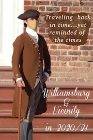
The image at the top of this page is the "Virginia Governor's Palace", home for all Virginia Governors until the Capital moved to Richmond in 1780.
Williamsburg founded in 1699, served as the colonial capital of Virginia and played a crucial role in early American history. As a center of politics, education, and culture, it was home to influential figures like Thomas Jefferson and Patrick Henry. The city thrived until the capital moved to Richmond in 1780, leading to its decline. However, in the 20th century, John D. Rockefeller Jr. spearheaded the restoration of Colonial Williamsburg, transforming it into the world’s largest living history museum. Today, Williamsburg preserves its past while embracing modern attractions, making it a key destination for history enthusiasts and travelers alike.
For a more in-depth discussion of Williamsburg, you should visit the Williamsburg Wikipedia Page.
The entire Williamsburg Colonial Center area is heavily forested, and the buildings are all either original, recreations or rebuilt original buildings in order to preserve the colonial "look & feel". For example, within the boundaries of Colonial Williamsburg are more than 500 original (restored) and reconstructed buildings. Colonial Center employees are all dressed in colonial style clothing.
Why Visit Williamsburg?
It was a simple decision because from our perspective, there were plenty of great reasons to explore this historic and vibrant area. The blend of extensive colonial history, fascinating museums, scenic landscapes, and unique attractions made it an easy choice. Whether it was the chance to step back in time at Colonial Williamsburg, walk the battlefields of the American Revolution, or simply enjoy the charm of a town that beautifully balances the past and present, we knew Williamsburg had something special to offer. So we decided to list our thoughts on why you should visit here:
Step Back in Time at Colonial Williamsburg:
One of the biggest draws to Williamsburg is Colonial Williamsburg, the world's largest living history museum. Here, visitors can step into the 18th century and experience life as it was during the American Revolution. Stroll down Duke of Gloucester Street, interact with costumed interpreters, and watch artisans practice traditional crafts like blacksmithing and shoemaking. Historical reenactments and guided tours bring the Revolutionary War era to life, making it an educational and immersive experience for all ages.
Explore the Historic Triangle:
Williamsburg is part of Virginia’s Historic Triangle, which also includes Jamestown and Yorktown. At Jamestown Settlement, visitors can explore replicas of the original fort and Powhatan village, gaining insight into America’s first permanent English colony. Meanwhile, Yorktown Battlefield offers a glimpse into the decisive battle that secured American independence. Each site is rich with exhibits, interactive displays, and stunning landscapes that make history both engaging and memorable.
Thrill and Chill at Busch Gardens and Water Country USA:
For those looking for a little excitement, Busch Gardens Williamsburg is a must-visit. This European-themed amusement park is known for its exhilarating roller coasters, live performances, and beautiful landscaping. During the summer, Water Country USA provides a refreshing escape with water slides, wave pools, and lazy rivers, perfect for families and thrill-seekers alike.
Savor the Local Flavors:
Williamsburg is a hidden gem for food lovers. From colonial-era taverns serving authentic 18th-century meals to modern farm-to-table restaurants, the city’s culinary scene is diverse and delicious. Don’t miss the chance to dine at Christiana Campbell’s Tavern, a favorite of George Washington, or sample craft beers at Alewerks Brewing Company. Wine enthusiasts can also visit the Williamsburg Winery, where they can sip on locally produced vintages amid scenic vineyards.
Enjoy Outdoor Adventures:
Nature lovers will find plenty to do in and around Williamsburg. The scenic Colonial Parkway, which connects Williamsburg to Jamestown and Yorktown, offers breathtaking views perfect for a leisurely drive or bike ride. The area is also home to lush parks, tranquil gardens, and opportunities for kayaking along the James River.
A Perfect Blend of Old and New:
Williamsburg’s charm lies in its ability to blend history with modern attractions, ensuring there’s something for every type of traveler. Whether you want to walk in the footsteps of America’s founders, experience adrenaline-pumping rides, or simply relax and enjoy the scenic surroundings, Williamsburg, VA, offers an unforgettable experience.

Colonial Williamsburg Parking:
Payments can only be made via a cell phone Application, available here. Part of the App Registration requires your license plate number, which allows them to monitor who in a parking area has properly indicated that they are using a parking spot. As you can see in the image to the left, these signs are scattered around the parking lot to make it simpler for you to follow the correct protocol; it is simple, fast and allows you to not have to worry about cash just to park!
WARNING: Some of the parking lots have no attendants and they are gated - you need to have the App to exit the lot!
Colonial Williamsburg Tickets:
Take a look at Colonial Williamsburg Tickets as there are multiple ticket types you may purchase. You do not need tickets just to walk about and enjoy the area or shopping, however, having at least a single-day ticket allows you to enter all of the buildings in the Colonial area, especially if you enjoy history and want to be able to see how people lived in Colonial Times. In addition, you will be contributing to the maintenance and care of Colonial Williamsburg.
Shopping in Williamsburg

The Williamsburg area offers a diverse and exciting shopping experience, catering to a wide range of tastes and interests. Whether you're looking for historical keepsakes, modern fashion, artisan crafts, or specialty goods, you'll find plenty of options to explore. In the heart of the colonial old town, charming shops transport visitors back in time, offering handcrafted items, period-accurate souvenirs, and unique finds inspired by 18th-century life. Beyond the historic district, Williamsburg is home to several shopping malls, bustling retail centers, and boutique stores, providing everything from high-end brands to locally made treasures. Additionally, numerous small shops are scattered throughout the colonial area, each with its own distinct charm and offerings. For a complete overview of shopping destinations, be sure to check out the Google Map of Shopping Locations (click the map link above) to plan your visit and discover the best places to browse and buy.
- Williamsburg Shopping:
This is on the "Visit Williamsburg" website, and it has a lot of good information; categories, locations, etc.
- Premium Outlets:
With over 125 stores; from Michael Kors to Ralph Lauren, this outlet village is a who's who of fashion favorites. Prepare to channel your inner stylist as you hunt for hidden gems and score last season's trends at rock-bottom prices.
- Top 10 Malls in Williamsburg:
Informative article providing you with where to go to find specific categories, locations of the malls, etc.
- Williamsburg Antique Mall:
The Williamsburg Antique Mall is a wonderland for history buffs and treasure hunters alike. Picture a sprawling 45,000 square feet teeming with antique furniture, vintage oddities, and collectibles whispering stories of yesteryear. It's a time machine disguised as a shopping spree, waiting to sweep you away on an exciting adventure.
- Merchants Square:
This open-air playground for history buffs is like Pinterest brought to life. Snag handmade candlesticks while a blacksmith clangs away, or grab a quill pen to write your next historical romance. Remember, haggling is encouraged!
- Williamsburg Pottery Factory:
Witness the magic of clay coming alive at this iconic factory. Watch the masters work their magic on the wheel, then snag a unique mug or vase for your morning coffee or living room shelf.
- Google Search Results List of Shopping Sites:
OK, so this list is just a basic search but you can resort this list using the Google filter features in any manner you require; sort by guest review rating, hours, etc.
All of the above images are from the shops near the intersection of the Duke of Gloucester Street and South Boundary Street. This is a nice area to explore, with various amounts of shade and benches to sit with one's dog.
Frequently Asked Questions about Williamsburg Virginia
Here are some of the most frequently asked questions about Williamsburg, Virginia:
- Where is Williamsburg located, and what is it known for?
Williamsburg is located in southeastern Virginia, between Richmond and Norfolk, and is part of the Historic Triangle alongside Jamestown and Yorktown. It is best known for Colonial Williamsburg, the largest living-history museum in the U.S., where visitors can experience 18th-century life through historic buildings, costumed interpreters, and reenactments. Williamsburg is also home to Busch Gardens, Jamestown Settlement, and the American Revolution Museum at Yorktown, making it a top destination for history, culture, and family-friendly entertainment.
- What is the best time of year to visit Williamsburg?
The best time to visit Williamsburg is during the spring (March–May) and fall (September–November) when the weather is mild, and the scenery is at its best with blooming flowers or vibrant autumn foliage. These seasons also offer fewer crowds compared to the busy summer months. Winter (December–February) is quieter and features festive holiday events, while summer (June–August) is popular for theme parks like Busch Gardens but can be hot and humid.
- Is Williamsburg a walkable city?
Yes, Williamsburg is a highly walkable city, especially in its historic areas. Colonial Williamsburg, the city’s main attraction, is designed for pedestrians, with cobblestone streets, preserved 18th-century buildings, and car-free zones that make exploring on foot easy and enjoyable. The adjacent Merchants Square offers a walkable mix of shops, restaurants, and cafes. While some areas, like Busch Gardens or the College of William & Mary, may require short drives, Williamsburg overall provides a pedestrian-friendly experience, particularly for visitors staying near the historic district.
- What are the major attractions in Williamsburg?
Williamsburg, Virginia, is home to a wealth of attractions that bring history, adventure, and culture to life. Colonial Williamsburg, the world’s largest living history museum, immerses visitors in the 18th century with costumed interpreters, preserved buildings, and interactive exhibits. Just a short drive away, Jamestown Settlement and Historic Jamestowne explore America’s first permanent English colony, while Yorktown Battlefield offers insights into the decisive battle of the American Revolution. For thrill-seekers, Busch Gardens Williamsburg delivers world-class roller coasters and family-friendly entertainment, while Water Country USA provides a refreshing escape during the summer. Shoppers and food lovers will enjoy Merchants Square, featuring boutique stores and top-rated restaurants. Outdoor enthusiasts can explore Freedom Park, the Virginia Capital Trail, or take a scenic cruise along the James River. Whether you're a history buff, nature lover, or adventure seeker, Williamsburg ffers something for everyone.
- Are there free things to do in Williamsburg?
Yes! You can explore parts of Colonial Williamsburg, visit the College of William & Mary, and walk along the scenic Duke of Gloucester Street.
- Is Williamsburg family-friendly?
Absolutely! Attractions like Busch Gardens, Water Country USA, and hands-on history sites make it great for kids.
- Can I visit Colonial Williamsburg without buying a ticket?
Yes, you can walk around the historic district for free, but tickets are required for entering buildings and special programs.
- Are there discount tickets avaiable for Colonial Williamsburg?
Yes, Colonial Williamsburg offers several discount passes and special offers, including the Good Neighbor Pass for locals, military discounts, and a Museums for All program for those receiving food assistance. Here is a link to the Colonial Williamsburg Website for more ticket information.
- Is Busch Gardens Williamsburg worth visiting?
Yes! It’s a highly rated theme park with roller coasters, family rides, seasonal events, and European-themed villages.
- Best places to eat in Williamsburg?
Williamsburg, Virginia, boasts a diverse culinary scene with top-rated restaurants that cater to every taste. For a historic dining experience, Christiana Campbell’s Tavern and King’s Arms Tavern serve authentic 18th-century fare in Colonial Williamsburg. Fat Canary, an award-winning fine dining restaurant in Merchants Square, offers gourmet dishes crafted with fresh, local ingredients. For farm-to-table freshness, The Hound’s Tale and Blue Talon Bistro provide innovative menus with a modern twist. Seafood lovers will enjoy Berret’s Seafood Restaurant, a local favorite for fresh oysters and coastal cuisine. Amber Ox Public House blends Southern flavors with craft beer for a unique gastropub experience.
Here is a link to a Google Search Results list for "restaurants in Williamsburg" sorted in "Guest Review Rating" order.
- Where should I stay in Williamsburg?
Williamsburg, VA, offers a variety of accommodations to suit every traveler, from historic inns to modern resorts. If you want to stay in the heart of history, Colonial Williamsburg Resorts, including the Williamsburg Inn and Williamsburg Lodge, provide elegant accommodations with easy access to historic sites. For family-friendly stays near Busch Gardens and Water Country USA, options like Great Wolf Lodge and Kingsmill Resort offer spacious rooms and fun amenities. Budget-conscious travelers can find comfortable stays at Hampton Inn & Suites, Best Western Historic Area Inn, or Holiday Inn Express Williamsburg. If you prefer a cozy, boutique experience, consider Fife & Drum Inn, a charming bed and breakfast in Merchants Square.
Here is a link to a Google Search Results list for "accommodations in Williamsburg" sorted in "Guest Review Rating" order.
- What is the brief history of Williamsburg?
Williamsburg, Virginia, is one of the most historically significant cities in the United States. Established in 1632 as Middle Plantation, it became the capital of the Virginia Colony in 1699, replacing Jamestown. During the 18th century, Williamsburg flourished as a political, cultural, and educational hub, playing a crucial role in the American Revolution. Leaders such as Thomas Jefferson, George Washington, and Patrick Henry walked its streets, debating the future of the colonies.
Today, Williamsburg is best known for Colonial Williamsburg, the world's largest living history museum, where visitors can step back in time to experience 18th-century life. The meticulously restored buildings, costumed interpreters, and historic reenactments bring the past to life, offering a glimpse into the struggles and triumphs of early American society. Along with Jamestown Settlement and Yorktown Battlefield, Williamsburg forms part of Virginia’s Historic Triangle, a must-visit destination for history lovers.
- Best Places to shop in Williamsburg?
Take a look at our list of shopping locations on this page, we've listed and linked them for your convenience.
Where is Williamsburg Virginia? Map
Williamsburg is located in southeastern Virginia, U.S., on a tidewater peninsula, between the James and York rivers, 27 miles (43 km) northwest of Newport News and 51 miles southeast of Richmond, VA.
Williamsburg Architecture
Nearly everywhere you look (see images below), you'll find stunning examples of colonial architecture, showcasing the history and charm of the area. These buildings, with their distinctive facades, intricate details, and timeless appeal, transport visitors to a bygone era. However, not all of these structures are original. Some have been meticulously restored to preserve their historical significance, while others are faithful re-creations, built to reflect the architectural style of the past. Whether original, restored, or reconstructed, each building contributes to the authentic colonial atmosphere, offering a glimpse into the region’s cultural and architectural heritage.
Williamsburg Restoration: For a good article on how Williamsburg was rebuilt/restored, click here
Williamsburg Street Scenes
Exploring Williamsburg (see images below) is an immersive experience that brings history to life at every turn. Simply strolling through the streets is an entertaining and enriching activity, as you'll encounter individuals dressed in authentic colonial attire, reenacting daily life from the 18th century. The charm extends to the many shops, taverns, and restaurants, where period-accurate décor, furnishings, and clothing create an atmosphere that feels like stepping back in time. Adding to the authenticity, the colonial area is entirely pedestrian-friendly, as cars are not permitted within its historic boundaries. This makes Williamsburg not only a delightful place to explore on foot but also an opportunity to fully immerse yourself in the sights, sounds, and spirit of early American history.
Click here to view a Google Images set for Williamsburg.
Virginia Beach in VA Map
Virginia Beach offers an irresistible blend of coastal relaxation and vibrant energy. Its pristine beaches stretch for miles, inviting you to soak up the sun, build sandcastles, or simply unwind. Beyond the shoreline, discover a thriving culinary scene featuring fresh seafood and local flavors. Immerse yourself in the city's rich history at First Landing State Park, where the first English settlers arrived in 1607. For adventure seekers, there's kayaking, fishing, and exploring the Chesapeake Bay.
Our visit came about as a day-trip from our hotel in Hampton, VA primarily because it was a beautiful day and secondarily because we had visited here often in the past.
USS Wisconsin BB-64 Museum Map
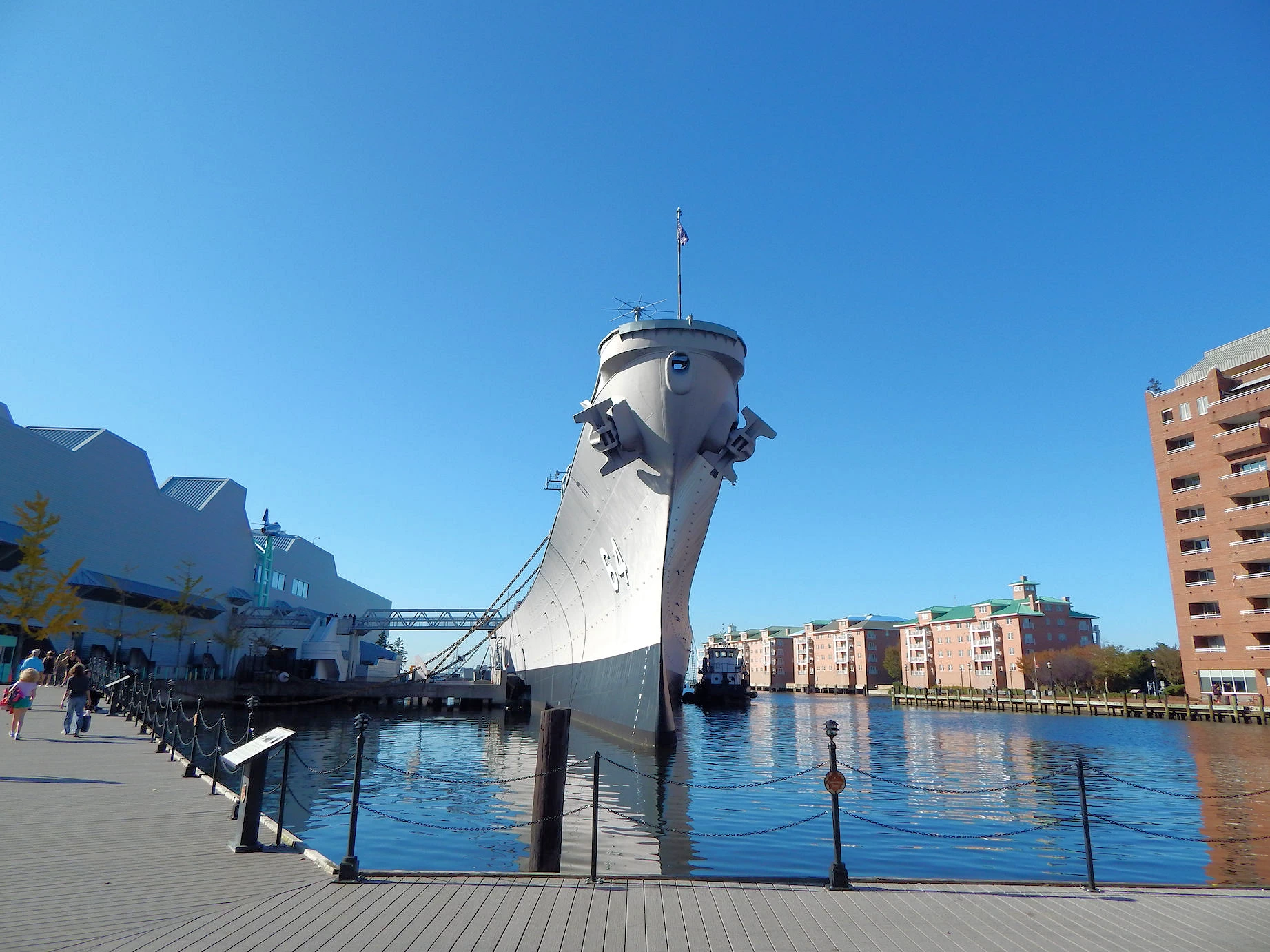
Since we were in the Norfolk general area, and we knew that the U.S.S. Wisconsin was now a museum near Norfolk, we decided to visit the museum and tour the ship.
Regardless of whether you were in the Navy or not, this class of Battleship is beautiful & very well preserved and has quite the history. The museum goes into all aspects of the ship's design, construction, war-time service, etc.
Parking is not intuitive at the museum location, but we will explain how to find public parking on the Wisconsin Battleship page. We will also provide a complete description of the ship's WW2 and later armament.
Click here to visit our USS Wisconsin BB-64 page.
Yorktown, VA Map
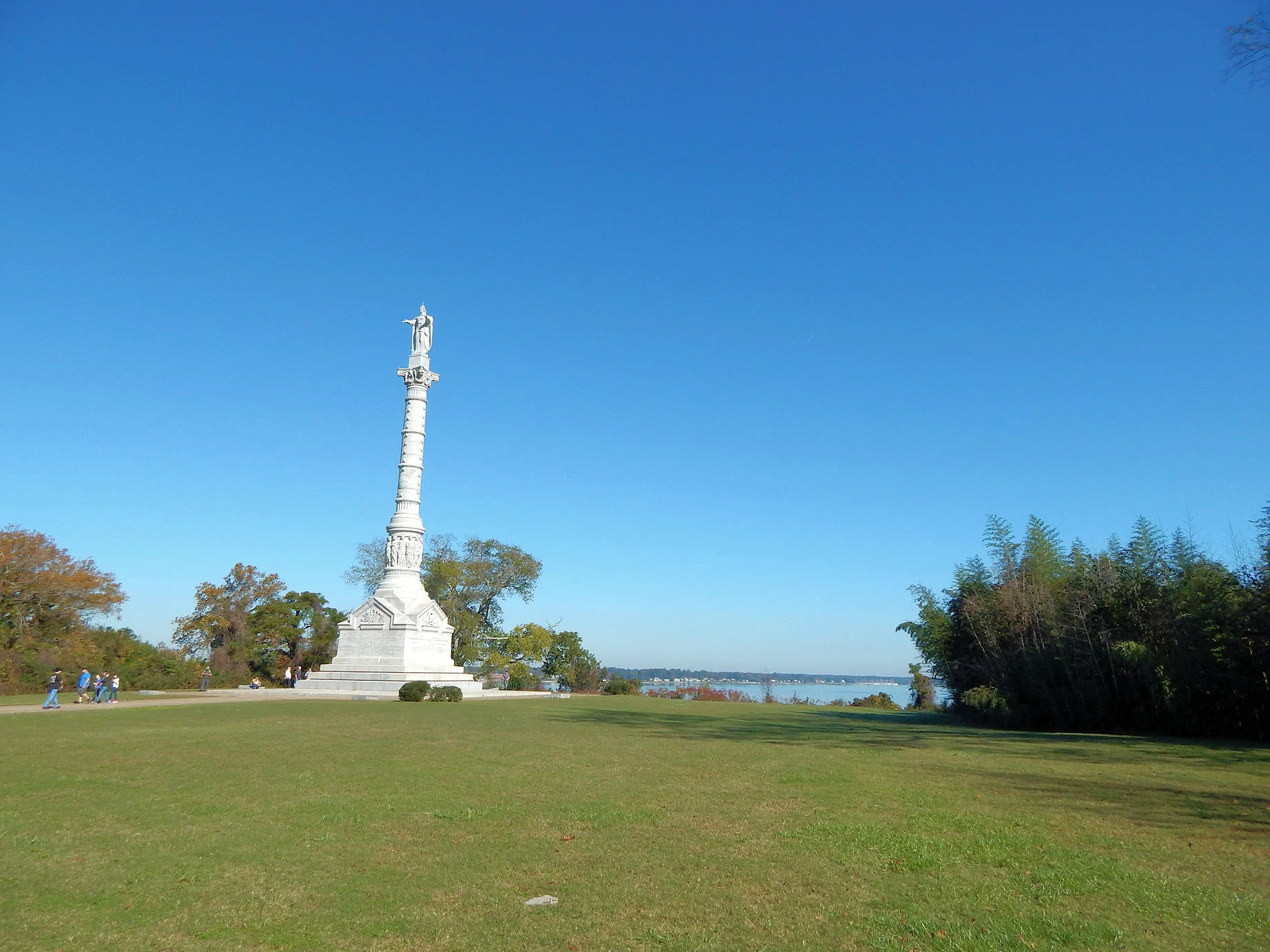
After we had completed our Colonial Williamsburg exploration, we decided to drive to Yorktown and explore the Yorktown Battlefield site and grab some lunch before we drove back to our cabin.
Click here to visit our Yorktown, VA page.
Some Useful Links for Williamsburg
Below you will find a set of useful links that we utilized while researching this trip. Each link listed will bring you to the relevant website.
- Just Traveling Thru Travel Planning Tips
- Things to do & see in Williamsburg on the "Visit Williamsburg" site
- Google Search Results list for "Williamsburg Restaurants"
- Google Search Results list for "accommodations in Williamsburg"
- Amazon Search Results list for "books about Williamsburg Virginia"
- Battleship Wisconsin Museum Site
- Virginia Beach Info on the "Visit Virginia Beach" site
- Yorktown Battlefield National Park on the "National Park Service" site
- Busch Gardens Williamsburg Website
- Colonial Jamestown Website
- Williamsburg Secrets Walking Tour from the "Get Your Guide" site
- Visit our Youtube Channel
- Our Image Gallery for Williamsburg
- Wikipedia Article for Williamsburg
- Google Image Gallery for Williamsburg
- Google Reviews for Williamsburg, VA
Note: All images featured on this page are the exclusive property of Just Traveling Thru, LLC, unless otherwise stated. When images from external sources are used, full credit is given to the original creator, along with a link to the specified license or usage terms. We are committed to respecting copyright and intellectual property rights, ensuring that all third-party images are properly attributed. If you have any questions regarding image ownership or usage rights, please feel free to contact us.
To review any of our content, make suggestions and/or comments, please click the "About" menu link at the top of this page. You will find our "Contact Us" link on that drop-down menu.


