Colorado National Monument
Discover Colorado National Monument's stunning red rock canyons, scenic drives, and hiking trails
by Celeste Lipford and Terry Lipford - last updated on 2/19/2025
Since we had never visited the Grand Junction area, and that was on our route to Moab, UT, we decided to explore the area. We discovered right away that the Colorado National Monument was something that looked beautiful and it was easy to access. So our first stop on the way to Utah was established. And before I forget to mention it, it was cold that morning - so if you visit here, bring warm clothing!
Interesting Colorado National Monument Facts
- Colorado National Monument is located is in the northeast area of the vast Colorado Plateau which is a landmass that covers the Four Corners region of the United States Southwest. The Colorado Plateau has the greatest concentration of U.S. National Park Service units in the country outside of Washington D.C. including the Grand Canyon, Arches National Park, Capitol Reef, Mesa Verde, Bears Ears, and more.
- John Otto mounted a one-man campaign to have his "backyard" declared a national park. That designation came in 1911, with Otto as its first superintendent. Otto famously wrote, "I came here last year and found these canyons, and they felt like the heart of the world to me. I'm going to stay and promote this place because it should be a national park."
- John Otto was a passionate explorer, and he was the first to extensively explore and promote the area. He even lived in the canyons and tirelessly worked to make it a national monument. He single-handedly carved many of the early trails and even used a pickaxe to build the first access routes into the monument.
- The area was originally inhabited by the Ute people, who used the canyons for hunting and shelter.
- The Colorado National Monument boasts canyons as deep as 500 feet and rock monoliths as tall as 450 feet.
- Construction of Rim Rock Drive began in the 1930s by the Civilian Conservation Corps and was completed in the '50s.
- Of the three tunnels along the 23-mile-long Rim Rock Drive, the longest is 530 feet long.
- Rim Rock Drive is also a popular and challenging road-biking route. It is home to the annual bike race called Tour of the Moon.
- Serpent's Trail, the original dirt road into the Monument and now its most popular hiking trail makes 54 switchbacks in just 2 1/2 miles.
- Colorado National Monument visitors often see mule deer and may also spot coyotes, mountain lions, bobcats, desert bighorns and much smaller mammals such as foxes, desert cottontails, squirrels, and other rodents.
- Colorado National Monument records an annual average of fewer than 12 inches of rain.
- The Colorado National Monument is 20,533 acres/83.09 square kilometers in size.
- The Colorado National Monument requires an entrance fee, but not a reservation. If you plan to camp there, you will need a campground reservation.
- The rock layers in the monument date back over 200 million years, with formations from the Triassic and Jurassic periods.
Where is the Colorado National Monument? Map
Our journey from Glenwood Springs, CO, took us westbound on I-70, a scenic stretch of highway that winds through the dramatic landscapes of western Colorado. Our plan for the day included a visit to Colorado National Monument, so we set out early in the morning, ensuring we had enough time to explore before continuing to Moab, UT, in time for dinner.
As we approached Grand Junction, we took Exit #24, leading us toward Rim Rock Drive, the southern entrance to the monument. This iconic 23-mile road is renowned for its breathtaking overlooks, sheer cliffs, and winding switchbacks, offering some of the most stunning views of the red rock canyons and towering monoliths.
We made several stops at designated pullouts, each offering a unique vantage point of the monument’s rugged terrain, deep canyons, and dramatic rock formations. The landscape is incredibly photogenic, with its fiery red and orange hues contrasting against the deep blue sky. We took time to walk along some of the shorter trails near the overlooks, stretching our legs while soaking in the unparalleled desert beauty.
Timing worked out perfectly—by the time we completed our scenic drive and exited the monument, it was lunchtime. We headed into Grand Junction for a meal, enjoying a well-earned break before getting back on the road toward Moab. The Colorado National Monument was a perfect detour, offering a spectacular taste of the American West’s natural grandeur while still fitting seamlessly into our travel schedule.
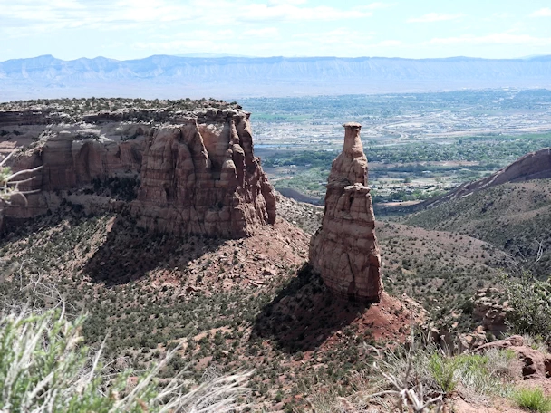
We had stopped at a pullout to get a picture of
Independence Monument
 Independence Monument is a striking sandstone formation located in Colorado National Monument
near Grand Junction. Standing at 450 feet tall, it is one of the park’s most iconic features. The monument's name
commemorates the Colorado Territory’s declaration of independence from Kansas Territory in 1861. Accessible via a
challenging hike, the trail to the base of Independence Monument offers breathtaking views of the surrounding canyons
and rock formations. Popular among climbers, the monument’s towering presence serves as a symbol of both natural beauty
and historical significance within the stunning landscape of Colorado National Monument.
and you can see Grand Junction in the background, so this
view is obviously looking east. This iconic 450-foot-high landmark is situated one mile southeast of the
monument's visitor center, and 9 miles (14 km) west of the community of Grand Junction, where it towers above the floor of Monument
and Wedding Canyons. We had previously seen this particular view of the Monument (only in pics) and as the day was very clear, we knew that our
pictures would turn out well.
Rim Rock Drive offers an awe-inspiring journey through the heart of Colorado National Monument, revealing the raw beauty of nature's artistry. This 23-mile serpentine road winds along the edge of deep canyons, offering panoramic vistas of rugged red rock formations, ancient monoliths, and the sweeping Colorado Plateau. As the sun's golden hues dance upon the cliffs and mesas, the drive becomes a visual symphony of color and texture. Along the route, numerous overlooks beckon travelers to pause and absorb the breathtaking views, including those of the Monument Canyon and Independence Monument. The drive is a testament to both engineering prowess and the preservation of the natural world, allowing visitors to marvel at the interplay of geological forces that shaped this dramatic landscape over millions of years. Rim Rock Drive is a pilgrimage into the heart of geological history, promising an unforgettable encounter with the grandeur of the American Southwest.
You need to exercise caution as you drive on this road, as it is a popular route for bicycle riders and we saw a number of groups going in both directions. In addition, there are a number of turnouts for viewing lots and hiking trails, so cars are entering and exiting the highway frequently.
Some Useful Links for the Colorado National Monument Facts
- Just Traveling Thru Travel Planning Tips
- 11 Top-Rated things to do in Grand Junction, CO on the "Planetware" site
- 14 Best Things to Do in Grand Junction, CO on the "Crazy Tourist" site
- Google Search Results list for "accommodations in or near Grand Junction, CO"
- Google Search Results list for "restaurants in or near Grand Junction, CO"
- View the Wikipedia Page for Colorado National Monument
- View a Google Images Set for Colorado National Monument
- Google Search Results list for "hiking in the Colorado National Monument area"
- Amazon Search Results list for "Colorado National Monument"
- Youtube Search Results list for "Colorado National Monument"
- Colorado National Monument: Ultimate Guide + Photo Tips on the "We Dream of Travel" site
Trip Itinerary
As you can see by the this map, our trip covered 3 different states, approximately 1,600 road miles and allowed us to see some spectacular geography. You might think that a trip of this distance would be something that would result in a "tired of driving" mood - but our stops were so diverse with such incredible geography and fun things to do, that we found that we looked forward to each morning to where we could continue our adventures!
Click any link below to go directly to that page;
Note: All images featured on this page are the exclusive property of Just Traveling Thru, LLC, unless otherwise stated. When images from external sources are used, full credit is given to the original creator, along with a link to the specified license or usage terms. We are committed to respecting copyright and intellectual property rights, ensuring that all third-party images are properly attributed. If you have any questions regarding image ownership or usage rights, please feel free to contact us.
To review any of our content, make suggestions and/or comments, please click the "About" menu link at the top of this page. You will find our "Contact Us" link on that drop-down menu.


