


Visit Bonita Point, CA
A Hidden Gem of California - Discover Bonita Point
by Celeste Lipford and Terry Lipford - last updated on 12/27/2024
This is not a well known major tourism destination, as it is not on the standard list of things to do & see in the San Francisco area. The Bonita Point Lighthouse is on the northern end of the Golden Gate Bridge and west of the 101 Interstate. This area was for a long time, an Army Artillery Post and you can still see the concrete block houses where the guns were positioned. The Army considered the artillery to be the "coastal defense" for San Francisco, as the weapons were intended to guard the western entrance to the Bay from the Pacific Ocean. During the Cold War era (1954), this area contained a Nike Missile Complex and then years later the entire area was turned over to California and became part of the Golden Gate National Recreation Area.
 Click above Image to view larger Google Map

 Click this image to watch a great overview video of our California trip. This video is the property of Just Traveling Thru, LLC.
If you enjoy our videos click here to subscribe to our Youtube Channel.

Fort Baker Map
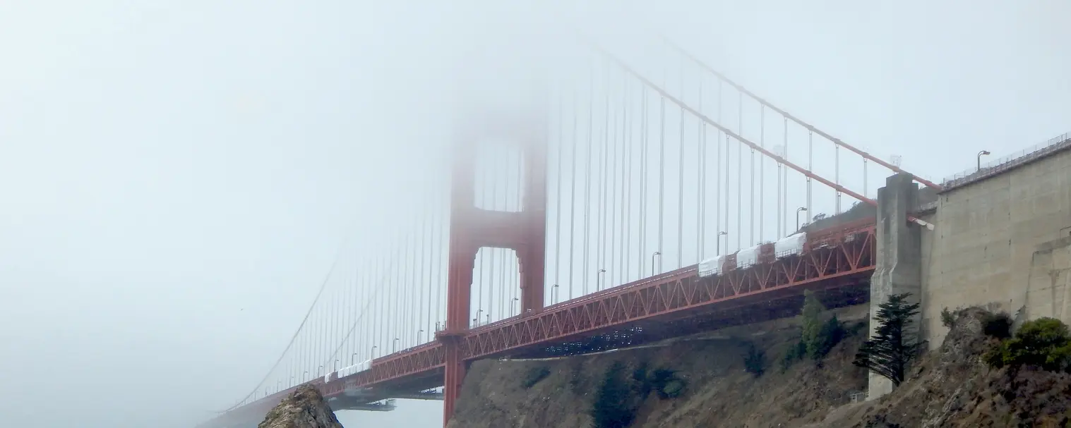
 Foggy Morning in San Francisco
 Waiting for the fog to dissipate
 Fort Baker Area
 Golden Gate Bridge Construction
 Baker-Barry Tunnel
 Bonita Point Directory Sign
Fort Baker, located near the northern end of the Golden Gate Bridge in California, has a rich history dating back to the 19th century. Originally part of the U.S. Army’s coastal defense system, it was established in the early 1900s to protect the San Francisco Bay from naval attacks. Fort Baker was one of several military posts, including Fort Point and Fort Barry, that formed a network of defenses guarding the entrance to the bay.
Construction of Fort Baker’s main structures began in 1901, including the historic barracks, officers' quarters, and artillery batteries. During World War I and World War II, the fort played a key role as a military base, with its artillery focused on defending against potential naval threats. However, no major military engagements took place there.
By the mid-20th century, with changing military strategies and the rise of air power, Fort Baker’s coastal defense role diminished, and it eventually ceased being a primary defense post. In 1972, Fort Baker became part of the Golden Gate National Recreation Area (GGNRA), transitioning from military use to public access.
Fort Baker also provides you with the opportunity to get very close to the northern base of the Golden Gate Bridge, and as can be seen, they were installing "suicide nets" on the bridge to prevent "bridge jumpers". Once we had completed our picture taking at Fort Baker, we drove back up the hill and crossed through to the Bonita Point Lighthouse side via the long single lane tunnel that connects the two areas.
NOTE: Be prepared to wait at the tunnel, it is a single lane and it is "time controlled" to allow cars from one side to proceed and even though there may be no cars waiting, the time has to expire before you are allowed to proceed.
More Info for Fort Baker
Image Credits:
- Image # 3 above Image Credit: National Park Service via their website. All other images are the property of Just Traveling Thru, LLC unless otherwise noted.
- All other images, unless otherwise noted, are the property of Just Traveling Thru, LLC.
Bonita Point Lighthouse 3D Map
 South Side of Bonita Point
 Harbor Seals on the Rocks
 Buildings of the old Military Base
 Bonita Point West View
 Bonita Point Lighthouse Access Tunnel
 Military Artillery Emplacement
Once we were allowed to drive through the single lane tunnel (traffic is allowed to move through in time intervals), we drove to the Bonita Point Trailhead, and began our exploration.
The Point Bonita Lighthouse, located at the entrance to the Golden Gate in California, has a storied history as a critical beacon for ships navigating the treacherous waters of the San Francisco Bay. Built in 1855, it was the third lighthouse on the U.S. West Coast. Initially constructed on a high cliff, the lighthouse’s location proved problematic, as fog often obscured its light from ships.
In 1877, the lighthouse was moved to a lower, more visible location on Point Bonita, where it still stands today. This new site, reached by a precarious path carved through rock, offered improved visibility to mariners. However, the terrain made access difficult, and in 1954, a suspension bridge was built to connect the lighthouse to the mainland, making it the only lighthouse in America that required crossing a bridge to reach.
In image # 3 above you can see how the fog is trying to obscure one of the barracks buildings. This type of building is where the Army Gun Crews lived while they were maintaining all of the guns. For you image "purists" out there, yes the building was a light green color and we have no idea why?
In image # 5 you can see that the final tunnel leading to the lighthouse is closed for repairs, as there was no other way to reach the lighthouse, that ended our hike.
In image # 6 you can see one of the original artillery gun emplacements. The guns have long since been removed, but they were mounted in those concrete block houses with a "pop-up carriage". This allowed the guns to popup, fire a shot, and then lower down again such that they were less likely to be hit by return fire. The concrete block houses are very strong and well built, so the Army just let them remain instead of destroying them. A volunteer veteran group (the "Fort Baker Retreat Group") helped restore them.
For you Military History enthusiasts out there, the artillery were 12 inch rifled guns utilizing Barbette Mounts and a barrel length of 436 inches. The concrete structures were two story, with powder and shells being kept below the gun level in their own rooms. The gun & carriage structure weighed approximately 120,000 pounds. These were big guns, and as just a comparison, Navy older Battleships such as the USS Arizona carried 14 inch guns - only slightly bigger than these Fort Baker guns.
 Bonita Point Lighthouse
Now if that last tunnel had not been locked, and we could have proceeded out to the lighthouse - this is what we would have seen. There has been a lighthouse in this location since 1855, and it was only after we researched why that final tunnel was locked that we found out that the Park Service only allows access to the lighthouse two days a week. Click here to go to the Wikipedia Page where you can find the full story about this lighthouse.
More Info for the Bonita Point Lighthouse
Image Credits:
- The above lighthouse & walkway image is the property of Frank Schulenburg via Wikipedia Commons using the CC BY-SA 4.0 license.
- All other images, unless otherwise noted, are the property of Just Traveling Thru, LLC.
Sausalito Map
 Richardson Bay from Sausalito
 Richardson Bay from Restaurant
 Sausalito Ferry headed to San Francisco
 Lunch at the Venice Gourmet Delicatessen
 Sausalito Exploration after Lunch
 The Inn Above Area
From Fort Baker it is an easy & short drive into Sausalito, where our intention was to have lunch and see some of this picturesque little town. We discovered the Venice Gourmet Delicatessen & Pizzeria with sidewalk seating - right in front of the waterfront. The food was excellent, service was prompt and efficient and the views were the icing on the cake!
As you can see in images 1 & 2, the fog was not present in Sausalito but was still very much lying over San Francisco. San Francisco is only 4 miles across the bay from Sausalito, but the weather for us that day was bright & clear. If you look at image # 2 which was taken looking south from the Venice Gourmet Deli, you can see that San Francisco is still covered by heavy fog.
NOTE: The Venice Gourmet Delicatessen & Pizzeria appears to no longer be in business as of 1/24/2024. It does still show up in Google Maps, but their website domain name shows a "website suspended" by GoDaddy.
Why we visited Sausalito: It is a picturesque waterfront town, known for its stunning bay views, vibrant art scene, and relaxed coastal charm. Visitors can explore art galleries, unique shops, and enjoy fresh seafood at waterfront restaurants. Outdoor activities include kayaking, biking, and hiking in the nearby Marin Headlands. Its colorful floating homes and iconic views of the Golden Gate Bridge make it a memorable Northern California destination.
The San Francisco / Sausalito Ferry is still operated and in our image # 6, the Sausalito Ferry Terminal is immediately behind the building you can see in that picture.
More Info for Sausalito California
Image Credits:
- All the above images, unless otherwise noted, are the property of Just Traveling Thru, LLC.
Some Useful Links for Bonita Point/Sausalito
- Just Traveling Thru Travel Planning Tips
- Wikipedia Sausalito Article
- Wikipedia Point Bonita Article
- Google search results list for "Restaurants in Sausalito"
- Google search results list for "accommodations in Sausalito"
- VRBO Rentals for the Sausalito area
- Google Images set for Sausalito
- Sausalito History at the "Sausalito Historical Society" Website
- Things to do and see in Sausalito on the "Planet Ware" Website
- Amazon Search Results list for "Sausalito California"
- Sausalito, Muir Woods, Bonita Point Tour from "Get Your Guide"
- Google Reviews for Bonita Point Lighthouse


Trip Itinerary & Overview Map
 Click above Image to view larger Google Map
As you can see in this static map, we had a number of destinations (as well as a number of side trips) that would require a considerable amount of driving. Each of the itinerary stops is linked to our content (or page) to allow you to view our content.
Locations / Start & End points are both San Francisco International Airport
- San Francisco Hilton Financial District.
- Bonita Point Lighthouse and Fort Baker area.
- Sausalito, CA.
- Santa Rosa, CA in the heart of the Sonoma County Wine District.
- Salida, CA - overnight rest stop along the way to Yosemite.
- Yosemite National Park, CA where we stayed at the Rush Creek Lodge.
- Frontieres Underground Garden Fresno, CA - this was an entertainment side stop, as we had read about this place and also wanted to get lunch.
- Santa Monica, CA
- Santa Barbara, CA
- Morro Bay, CA.
- Monterey Bay, CA to explore the Monterey Bay and Carmel by the Sea areas.
Note: All images featured on this page are the exclusive property of Just Traveling Thru, LLC, unless otherwise stated. When images from external sources are used, full credit is given to the original creator, along with a link to the specified license or usage terms. We are committed to respecting copyright and intellectual property rights, ensuring that all third-party images are properly attributed. If you have any questions regarding image ownership or usage rights, please feel free to contact us.
To review any of our content, make suggestions and/or comments, please click the "About" menu link at the top of this page. You will find our "Contact Us" link on that drop-down menu.